Park Map
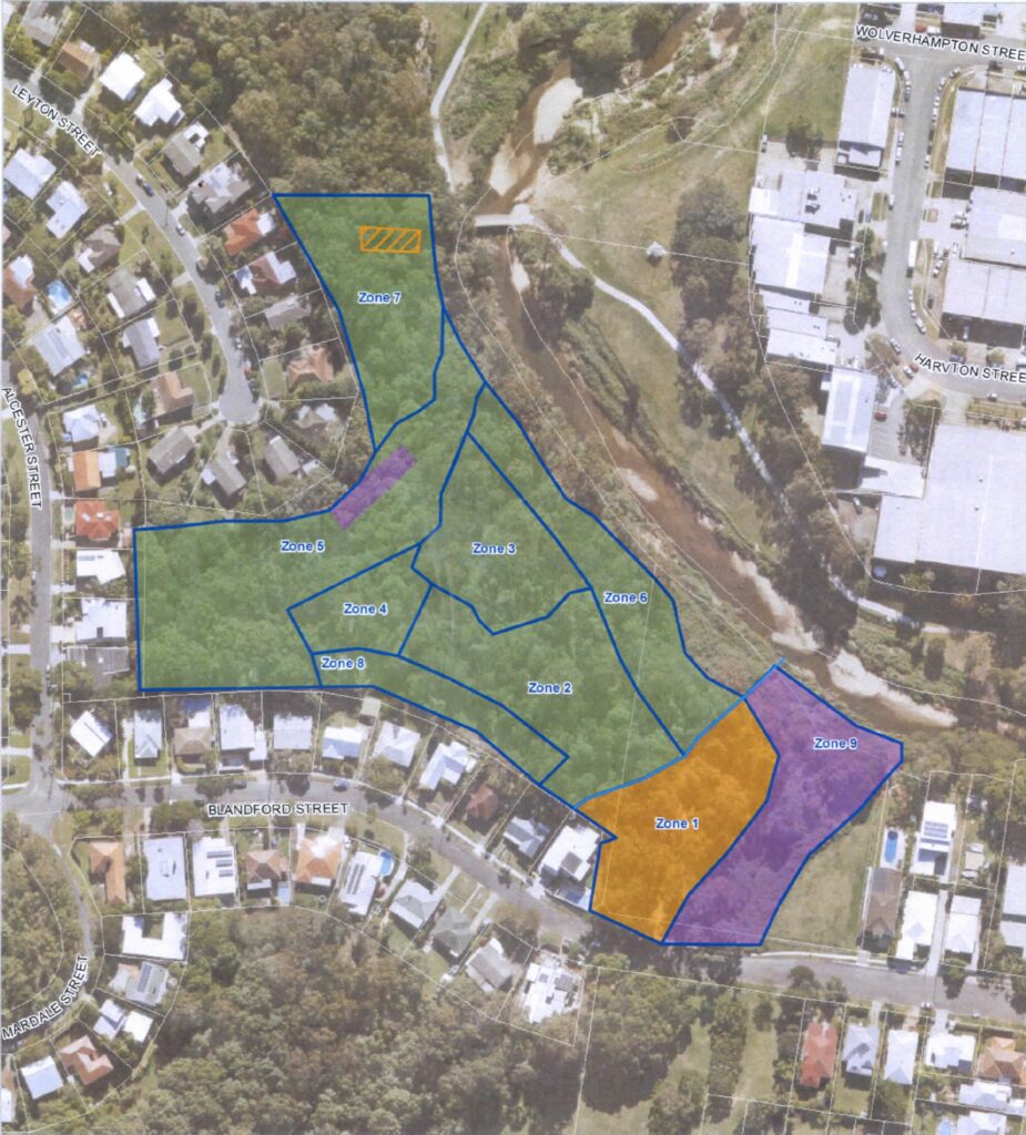
For ease of management the park has been divided into different areas each with its own specific ecology and management requirements.
ZONE 1 – THE BLANDFORD STREET ENTRANCE AREA
This area (highlighted in yellow) is the start of the public footpath through the park and is also a service entrance for vehicles. It includes a mown area regularly serviced by the BCC. Extending north from the entrance towards Kedron Brook is an area that has been heavily planted over the years and has formed a self-mulching canopy. Two of the park’s most mature gums (Eucalyptus tereticornis) occur in this area. To the east and further north are a gully and flood plain areas heavily infested with weeds, especially vines (Madeira vine, morning glory etc). The GreenBrook toolshed is located in the entrance area and also a BCC tap. Because of potential soil contamination in this zone the BCC have designated this a ‘No Dig’ area.
ZONE 2 – THE BUSHLAND AREA
This is an area that has been extensively planted through the years and has established a self-mulching canopy, although recent droughts have caused some die back. The eastern boundary is a natural gully which once included a small semi-permanent pool. In recent years this pool has dried up. The northern boundary is formed by the walking track through the park and the southern boundary backs onto a mown firebreak area (Zone 8) serviced by the BCC. This firebreak is separated from the park by a line of large logs and a thick band of Lomandra longifolia forming a barrier preventing weed egress. This boundary also seems to discourage domestic dumping of garden rubbish from nearby houses. The Eastern section of this area is more heavily planted with rainforest natives that utilise the extra soil moisture from suburban run off. The western section is more open sclerophyll forest. Some of the planted natives are now regenerating. There is a BCC tap at Western end of the adjacent firebreak.
ZONE 3 – THE GRASSLAND AREA
This area represents an experiment to return to a more open grassland environment with isolated large trees. (From early descriptions at the time of settlement this seems to have been the nature of large tracts of land around Brisbane.) The area was cleared of saplings (mostly a monoculture of immature brush box (Lophostemon confertus)) several years ago, leaving only a few larger trees (e.g. Eucalyptus propinqua). Some native grasses were planted (Themeda triandra, Imperata cylindrica). With the opening of the canopy, grasses have flourished and 11 species of native grasses have been identified. This has been a successful experiment and the different habitat encourages a greater diversity of fauna in the park.
ZONE 4 – THE GULLY AREA
This small gully is a buffer between the grassland areas and the rainforest gully. Like so many other natural gullies in Brisbane it has experienced considerable dumping of domestic rubbish over the years. Recently extensively planted, the trees are beginning to establish a canopy. A couple of native bees’ nests can be located in this zone. There is a BCC tap at the Western end of the adjacent firebreak.
ZONE 5 – THE RAINFOREST GULLY AREA
This steep sided gully serves as a major storm water run-off channel flowing rapidly into Kedron Brook during times of heavy rain. Historically it has been used as a dumping spot and the steep banks behind houses abutting this area are littered with deposits of domestic rubbish. This area was heavily planted over 20 years ago with many native rainforest species – largely selected to attract butterflies. Many of these trees are now well established and it is pleasing to note that the gully has a rainforest feel and often hosts a variety of butterflies. The head of the gully was the site of major works by the BCC many years ago to extend the storm water exit point. This has greatly helped in controlling weeds in the head of the gully. At the northern end of the gully and on the western bank weeds are still an issue but for safety reasons the area highlighted in purple on the map is a ‘No Access’ area for our group. Erosion due to rapid storm water runoff is an ongoing issue especially in the lower reaches of the gully as it approaches Kedron Brook.
ZONE 6 – THE TRACK AREA
This narrow stretch of bushland extends north from the walking track to the banks of Kedron Brook. The north eastern edge is defined by the steep erosion banks that separate the park from the lower flood plains of the Brook. These lower banks are a major source of weed and vine infestations continually refreshed each time Kedron Brook breaks its banks. Some planting has taken place over the years at the south eastern end of this zone but outside of weeding this area has not been given a lot of attention. A Moreton Bay fig planted at the base of the erosion banks to commemorate September 11th 2001 is now well established.
ZONE 7 – GREG’S AREA
This tract of bushland represents the northern limit of the park that the group now maintains. It is named in honour of Greg Smith whose house abuts this area and who has devoted countless hours to maintaining the park. On the northern edge it is bounded by the “clay flats” – a distinctive area that is all that remains of a large hill removed for fill at Brisbane airport during the second world war. With the onset of the pandemic this area has become popular with BMX bike enthusiasts who have improvised innumerable dirt bike paths. Unfortunately this causes destruction of flora, disruption to wildlife and dust problems for locals. The BCC is struggling to control these illegitimate activities.
ZONE 8 – THE FIREBREAK
This firebreak protects houses adjoining the bushland from fire and is regularly mown by the BCC. Service vehicles also use it to access the park.
ZONE 9 – THE EASTERN GULLY AND FLOOD BANKS OF THE BROOK
The Eastern Gully (shaded in purple) is historically an old dump site and is a wild, unmaintained area that suffers extreme weed infestations (especially vines). The eastern bank of this gully was the site of an old tannery. The BCC is currently investigating remediation of this area and in the meantime it is deemed a ‘No Access’ area to the group. The lower banks of Kedron Brook flood regularly and are a site of many weed and vine infestations. It is beyond the current capacity of the group to attempt to maintain this area.